Category Archives: History

Tarantulas looking for love near Folsom Lake

Tarantulas are out looking for love and hikers are being warned to look out for them.

Last weekend, while hiking along the Darington Trail near Folsom Lake, ABC10’s John Bartell came across one of those hairy arachnids. A group of mountain bikers warned John and his girlfriend, who were on the trail at the time, of a tarantula. A surprisingly large tarantula. If you listen closely to the video, you can hear John’s girlfriend warn him about picking up the eight-legged creature.

Wade Spencer, a member of the UC Davis Entomology Department, works with spiders. He said tarantulas can bite, but only if they are only aggressive when agitated. Though they have fangs and carry poison, tarantulas are not considered a serious threat to humans.

More at ABC10.com >>>

Why are salmon dying? (Hint: It’s a good thing…)

Dead salmon are washing up on banks of the American River. It sounds gruesome but it’s actually a good thing.
The annual salmon run is underway and the fish have traveled thousands of miles to spawn then die in our waterways.
“Within the last decade we have seen a downward trend,” said Department of Fish and Wildlife researcher Jeana Phillips. The DFW keeps a close eye on the salmon population. Every year a team of researchers count dead salmon after they have spawned.
The American River Nimbus Fish Hatchery in Rancho Cordova is full of salmon right now. A number of salmon in the American River were released from the Nimbus Fish Hatchery. Salmon hatch in rivers then make their way to the ocean where they spend 3 to 4 years. When they are ready to breed. Salmon leave the ocean, head back to the area they were born, lay eggs, then die.
More at ABC10.com >>>


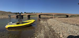
Original Salmon Falls Bridge Resurfaces At Folsom Lake

Salmon Falls Bridge

With water levels receding at Folsom Lake, old little snapshots of history are reappearing.

As documented by the Placer County Sheriff’s Office over the weekend, the orginal Salmon Falls Bridge has reappeared due to the low water levels.

The bridge is among the last remnants of the historic colony on Mormon Island. Back in Gold Rush times, the colony housed more than 2,500 residents. A devastating fire tore through the settlement in 1856 and it was never rebuilt.

More at CBSLocal.com >>>

California high court upholds ban on dredges to extract gold

California’s ban on the use of suction dredges to extract gold from rivers is legal and not overridden by a 19th century federal law that allows mining on federal land, the California Supreme Court ruled Monday.

The court’s unanimous decision was a victory for environmentalists and a blow to miners, who argued that the ban essentially stopped gold mining because doing it by hand is labor intensive and makes the enterprise unprofitable.

Environmentalists say suction dredge mining risks killing fish and stirring up toxic mercury.

The high court’s ruling came in an appeal of a criminal case in which miner Brandon Rinehart was convicted of a misdemeanor for suction dredge mining without a permit in 2012 and sentenced to three years of probation.

Associate Justice Kathryn Werdegar, writing for the court, said the federal Mining Law of 1872 did not guarantee a right to mine free from regulation.

Instead, its goal was to protect miners’ property rights involving the federal land to which they laid claim, she said.

“The mining laws were neither a guarantee that mining would prove feasible nor a grant of immunity against local regulation, but simply an assurance that the ultimate original landowner, the United States, would not interfere by asserting its own property rights,” she wrote.

Rinehart’s attorney, James Buchal, said the high court showed a “casual disregard” for federal law.

He said Rinehart would likely ask the court to review its ruling or appeal to the U.S. Supreme Court.

Suction dredges are powerful underwater vacuums that suck up rocks, gravel and sand from riverbeds to filter out gold.

More at USNews.com >>>

Natomas Levee Project Ready To Begin

The U.S. Army Corps of Engineers has the go-ahead to begin a nine-part levee-improvement project for the Natomas Basin in Sacramento.

The final documents required for the project have been signed and the Army Corps will put the first section of levee repair out to bid this fall. The levees are part of a system that diverts watershed runoff into the American River.

John Hogue is the project manager for the corps. He says each of the nine repair projects is called a “reach” and includes construction of a cutoff wall to prevent seepage. He says each reach project will present its own set of obstacles.

More at CapRadio.org >>>

California’s outdoor writers flock to Auburn, Placer County

They came. They saw. They were conquered – by Placer County’s outdoor attractions.

That was the consensus of local tourism industry spokespeople after 58 writers and photographers with the Outdoor Writers Association of California were treated to a variety of opportunities to explore and learn about Placer County’s outdoor amenities as part of the group’s conference Sunday and Monday in Auburn.

Bob Semerau, association president emeritus, had praise Tuesday for organizers and Auburn attractions.

“Experiencing the broad spectrum of outdoor adventure opportunities to be found in Placer County has given the membership a real appreciation for this lovely part of California,” Semerau said. “Fly fishing the middle fork of the American River with Grady Garlough of Rise Up River Trips highlighted the pristine and wild natural beauty to be found throughout the region. And the fishing was awesome.”

Mora Rowe, Placer County Visitors Bureau executive director, said Tuesday that many facets of the county’s outdoor tourism-based industry were presented to the organization in tours and recreational opportunities.

They included bass fishing on Folsom Lake, a tour of ancient geology and watersheds in the Foresthill area and target practice at the Auburn Trap Shooting Club. At the Auburn Quarry near Cool, experienced rock climbers were offered the opportunity to climb a cliff.

More at AuburnJournal.com >>>

Levee ‘armoring’ along the American River Parkway draws concerns

Years of rumbling dump trucks and backhoes placing 2.75 million tons of rock “armor” along nearly a dozen miles of riverbank is an unpleasant thought for many who bike, jog, fish, bird-watch, golf, boat and swim along the lower American River Parkway.

But to demonstrate why officials currently are planning for some version of that scenario, Rick Johnson, the executive director of the Sacramento Area Flood Control Agency, points to a striking aerial photo taken after one of the worst deluges ever recorded in this region.

The photo was snapped in February 1986 after an extraordinary Pineapple Express storm filled reservoirs and rivers and pushed Sacramento’s flood infrastructure to its limits. The image shows an area near where the Capital City Freeway crosses the American River; it looks as if several giant bites had been taken out of the massive levee there.

Just on the other side of the levee sits the River Park neighborhood. If the rushing river – which at one point was surging with more than a million gallons per second – had eaten away just a few more feet of the barrier, Sacramento would have been awash in floodwater that would have rivaled what swamped New Orleans during Hurricane Katrina. Tens of thousands of homes could have been flooded.

But it wasn’t until the American River receded that anyone knew how close the city had come to disaster.

“The scary part is you couldn’t see (the damage to the levee). It was all underwater,” Johnson said. “We didn’t even know that was happening until after the water came down. They should have evacuated, quite frankly.”

Prompted by recent changes in state and federal flood control policy – largely in reaction to Katrina – local officials and the U.S. Army Corps of Engineers are in the initial phases of planning a $375 million project that would add a layer of rocky erosion protection along up to 11 miles of the lower American River.

The levees under consideration stretch along segments of the American River, starting where it meets the Sacramento River near downtown and ending upstream near the Butterfield neighborhood, which is about 4 miles east of the Watt Avenue bridge.

The project has presented flood control officials with a major challenge: How do they balance the need to armor the levees against erosion while at the same time protecting – or restoring after construction – the stream-side riparian habitat, as well as the trails and river access that make the lower American River Parkway a local treasure?

More at SacBee.com >>>

Folsom Lake level reaches important milestone

Sunday Jan. 31 will be remembered as the day Folsom Lake recovered.

In less than two months, Folsom Lake has gone from the lowest level in its 60-year history to above average for this time of year.

According to preliminary data from the California Department of Water Resources, Folsom Lake rose from below average to above average sometime between 4 and 5 a.m. Sunday.

As of 5 a.m., Folsom Lake held 507,193 acre feet (AF) of water. The average for Jan. 31 is 506,849 AF.

An acre foot of water will supply the average household for a year.

On Sunday morning, the lake level stood at 418 feet above sea level, roughly 70 feet higher than when it bottomed out on Dec. 4 with just 135,561 AF.

Like it or not, Folsom Lake will likely soon shift roles from water storage to flood control.

More at News10.net >>>

Folsom Lake Water Level Shrinks To New Historic Low

The water level of Folsom Lake has dipped to a new historic low.

On Sunday the lake level was measured at 140,410 acre feet. The previous record was set in November 1977 when the lake decreased to 140,600 acre feet.

Recent rain has provided a little help, but there’s still a long way to go.

“We may have a very wet winter, but if we don’t have dramatic snowfall and so forth we’ve got to still be conscious we’re still living through this drought,” he Rep. Ami Bera during a recent tour of the lake.

As has been long discussed, Bera says the state must find better ways to store water and he’s pushing the proposed Sites Reservoir, a potential water storage option west of Colusa. The planned reservoir would hold twice the water of Folsom Lake.

More at CBSLocal.com >>>

Folsom Lake hits lowest depths in 20-plus years

Even as Sacramento waits for the soaking El Niño forecast to hit this fall, Folsom Lake continues to lose water and will almost certainly fall Thursday to its lowest level in more than 20 years, government data show.

Folsom Lake provides drinking water to hundreds of thousands of residents in the Sacramento region. Releases from the federal reservoir also serve as a bulwark against Sacramento-San Joaquin Delta saltwater intrusion, and are critical to maintaining the delicate ecosystem of the lower American River.

Folsom Lake became the face of California’s drought early last year when aerial photos of its moonscape lake bed were broadcast nationwide. At its lowest point last year, the lake level was the same as what the reservoir contained Wednesday. By Thursday, the reservoir is expected to fall to levels last seen in 1992, at the tail end of a five-year drought. And by month’s end, the depth likely will approach levels not seen since the great drought of 1977.

Area water officials said they are concerned about the dwindling supply but expressed relief that lake depths are not even lower. The U.S. Bureau of Reclamation, which operates the reservoir, initially warned that the lake could fall to 120,000 acre-feet by the end of September.

“The situation has been so rough,” said bureau spokesman Shane Hunt. “We are doing everything we can to make sure we maintain water supplies to homes.”

Still, he added, “We are better than a worst-case scenario.”

More at SacBee.com>>>