
Category Archives: Bike Trail
Planned Water Deliveries Increases Following Recent Storms
On Feb. 25, the California Department of Water Resources (DWR) announced that recent storms have allowed for another increase to the State Water Project (SWP) allocation forecast for 2025.
The allocation has increased to 35 percent of requested water supplies, up from 20 percent in January based on increases in precipitation, snowpack and reservoir storage. The State Water Project provides water to 29 public water agencies that serve 27-million Californians and 750,000 acres of farmland across the state.
The latest allocation forecast takes into account precipitation and snowpack conditions up to Feb. 10, prior to a cold storm that brought welcome snow to the Sierra. That snowpack will be included in future water supply calculations, along with any forecasted dry conditions ahead.
Aftershock Announces 2025 Lineup: Deftones, Blink-182, Korn, Marilyn Manson Among Headliners
A massive lineup of rock legends will be rolling through Discovery Park in Sacramento for Aftershock 2025.
The lineup for this year’s Aftershock festival was announced on Wednesday. More than 115 bands will be playing across the four stages from Oct. 2-5 for the festival.
Opening night honors will go to Blink-182, with All Time Low, Taking Back Sunday and Alkaline Trio also listed as top acts for the day.
Volunteers Find 19,000 Needles While Picking Up Trash Around Local Waterways
The group’s co-founders believe the problem stems from needle exchange programs that are giving away needles instead of requiring an exchange.
A volunteer organization is alerting people about the massive amount of needles they’re finding in and along Sacramento waterways.
The River City Waterway Alliance showed ABC10 a photo of more than 19,000 needles they’ve removed in the past two years.
Folsom Lake Bike Trail To Temporarily Close
California State Parks, in collaboration with the Sacramento Municipal Utilities District, will intermittently close a segment of the American River Bike Trail within Folsom Lake State Recreation Area this month for a utility undergrounding project.
Starting March 17, the trail will be closed from 8 a.m. to 5 p.m. Monday through Friday between Mountain Oak Court and the Rainbow Bridge, as shown on the map below. State Parks expects to reopen the trail by April 1.
This trail closure is necessary for SMUD to install utilities beneath the bike path. During construction hours, there will be no designated detour route, and trail users are encouraged to find an alternate path. Outside of construction hours, the trail will remain open but be reduced to a single travel lane.
7-foot Tall Model Of Folsom River District To Highlight Development’s Next Steps
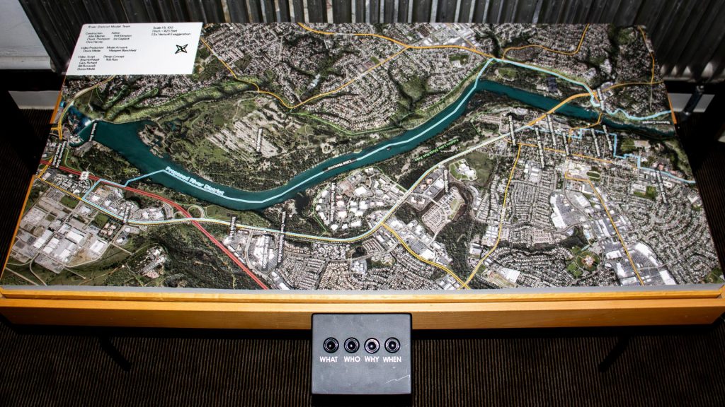
In February 2025, Folsom unveiled an interactive scale model as part of its River District Master Plan, aiming to enhance public engagement and awareness. This model, measuring approximately 7 feet tall, 6 feet long, and 2.5 feet wide, was designed to familiarize residents with the development plans along the over six-mile stretch of the American River and Lake Natoma.
The River District Master Plan focuses on several key objectives: increasing public access to the river and lake, expanding recreational opportunities, fostering economic development, ensuring high-quality design, preserving Folsom’s heritage, protecting environmental, cultural, and historical resources, recognizing city gateway opportunities, and integrating both old and new areas of the city.
Rob Ross, a 20-year Folsom resident and member of the River District Organizing Committee, emphasized the importance of enhancing river access and enjoyment for the community. The portable model, equipped with lights and screens, serves as a tool to inform and involve residents in the city’s development plans, ensuring that Folsom maintains its small-town charm amidst growth.
This initiative reflects Folsom’s commitment to thoughtful urban planning and community involvement, aiming to balance development with the preservation of natural and cultural assets.
Protesters Try To Stop County From Reopening Sailor Bar Road
In Fair Oaks, Sacramento County is set to refurbish a beloved section of the American River Parkway, known as Sailor Bar, which has been off-limits to vehicles for over ten years. This area, cherished for dog walking, fishing, and nature appreciation, traces its roots to the Gold Rush era when it was a bustling mining site. Today, it’s a haven for wildlife enthusiasts, offering glimpses of herons, bald eagles, foxes, coyotes, and bobcats.
The county’s initiative aims to reopen three existing dirt and gravel roads, closed to vehicular traffic 15 years ago due to budget constraints. With increased staffing, the Parks Department plans to enhance these roads, facilitating better access for fishermen and families seeking riverside picnics.
However, local residents are voicing concerns. They fear that reintroducing vehicles could escalate issues like illegal dumping, drug use, and heighten fire risks, especially given the area’s sloped terrains prone to becoming tinderboxes during summer. Advocates for preserving the current state argue that the area’s tranquility and ecological balance might be disrupted by vehicular presence.
While some community members support the move, citing improved accessibility for activities like fishing, opponents have initiated an online petition. They are urging the Board of Supervisors to conduct a public hearing to address the controversy before the planned reopening of the roads this spring.
Truxel Bridge Design OK’d By Sacramento City Council
The Truxel Bridge design has been approved, paving the way for improved access to the American River Parkway.
This project aims to enhance connectivity and support the area’s natural beauty, making it easier for residents and visitors to enjoy outdoor activities along the iconic river.
The bridge will not only serve practical transportation needs but will also deepen appreciation for the scenic landscapes and recreational opportunities the American River offers.
With this new infrastructure, the parkway is set to become even more inviting for nature lovers and adventurers alike.
Local nonprofit cleans up 36,000 pounds of trash along American River
SACRAMENTO — A local nonprofit helped remove tens of thousands of pounds of trash from the Riverdale area along the American River.
A small army of volunteers rolled out into the area on a mission to make the area beautiful again after storms flooded out homeless encampments there weeks ago.
Mark Baker and volunteers with the River City Waterway Alliance cleared out 36,000 pounds of trash along with the help of folks like Randy Smith.
More >> https://www.cbsnews.com/sacramento/news/local-nonprofit-cleans-up-36000-pounds-of-trash-along-american-river/
Nutria Discovered in San Joaquin Valley; CDFW Seeks to Prevent Further Spread and Infestation
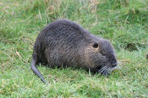
The California Department of Fish and Wildlife (CDFW) has become aware of a population of invasive nutria (Myocastor coypus) reproducing within the San Joaquin Valley. Given the severity of potential impacts and the impacts realized in other infested states, CDFW believes early intervention actions could be successful in eradicating nutria from the area and is asking the public’s help in looking for and reporting nutria sightings in order to determine the extent of the infestation.
To date, nutria have been found in wetlands, rivers, canals and other freshwater habitat in Merced, Fresno and Stanislaus counties. If allowed to establish, nutria will severely impact California’s resources, causing the loss of wetlands, severe soil erosion, damage to agricultural crops and levees and reduced stability of banks, dikes and roadbeds, as they have done in Louisiana, Chesapeake Bay and the Pacific Northwest. Nutria also degrade water quality and contaminate drinking supplies with parasites and diseases transmissible to humans, livestock and pets.
Native to South America, nutria are large, semi-aquatic rodents that reach up to 2.5 feet in body length, 12-inch tail length and 20 pounds in weight. Nutria strongly resemble native beaver and muskrat, but are distinguished by their round, sparsely haired tails and white whiskers (see CDFW’s Nutria Identification Guide). Both nutria and muskrat often have white muzzles, but muskrats have dark whiskers, nearly triangular (laterally compressed) tails and reach a maximum size of five pounds. Beavers have wide, flattened tails and dark whiskers and reach up to 60 pounds.
Female nutria are reproductive by six months of age, breed year-round, and can produce three litters in 13 months. Within approximately one year of reaching reproductive maturity, one female nutria can result in more than 200 offspring, which can disperse as far as 50 miles.
Nutria are destructive, wasteful feeders that destroy up to 10 times the vegetation they consume. Signs of presence typically include cut, emergent vegetation (e.g. cattails and bulrushes), with only the base portions eaten and the stems left floating. Nutria construct burrows with entrances typically below the water line, though changing water levels may reveal openings. Similar to other aquatic mammals, nutria often create runs, or paths in and out of the water or between aquatic sites. Nutria tracks have four visible front toes and, on their hind feet, webbing between four of five toes. Tracks are often accompanied by narrow tail drags.
Since March 30, 2017, more than 20 nutria, including males, pregnant females and juveniles, have been documented within private wetlands near Gustine, duck clubs, the Merced River near Cressey, adjacent to the San Joaquin River near Grayson, south of Dos Palos, the San Luis National Wildlife Refuge, and Salt Slough on the San Joaquin River. The full extent of the infestation is not yet known.
A multiagency Nutria Response Team, which includes representatives from CDFW, the California Departments of Food and Agriculture, Parks and Recreation, and Water Resources, the U.S. Department of Agriculture, the U.S. Fish and Wildlife Service and local county agricultural commissioner offices, has convened with the goal of eradicating nutria from the state. The response team is currently preparing an eradication plan, the first stage of which is determining the full extent of the infestation. Assistance from local landowners and the public throughout the Central Valley, Sacramento-San Joaquin Delta and beyond is critical to successfully delineating the population.
Suspected observations or potential signs of nutria should be photographed and immediately reported to CDFW’s Invasive Species Program online, by e-mail to invasives@wildlife.ca.gov, or by phone at (866) 440-9530. Observations on state or federal lands should be immediately reported to local agency staff at that land. CDFW has a nutria webpage and a downloadable PDF with photos and detailed descriptions of these rodents, their preferred habitat and the environmental threats they present.