Category Archives: Water

Progress At Folsom Dam Spillway

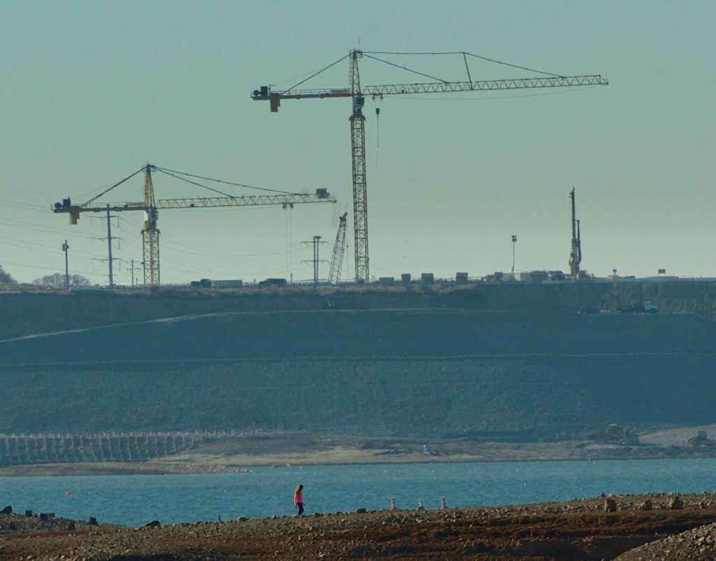
MormonIsland 2An $802 million project to bolster Folsom Dam is going full bore — and hiring hundreds of local workers and dozens of vendors in the process.

Construction of the control structure — the third in four phases of the Folsom Dam Auxiliary Spillway Project — is nearly complete, says the U.S. Army Corps of Engineers, the agency spearheading the project.

The project has brought heavy construction equipment and occasional blasting to the area of Folsom Lake Crossing since 2007. It is meant to help the dam control water flow more efficiently if there is a high-water event — and help Sacramento meet its required level of 200-year flood protection.

More at BizJournals.com >>>

Fish And Game Commission Adopts Emergency Regulations To Close Angling

Taking swift action in response to severe drought conditions throughout the state, the California Fish and Game Commission today adopted emergency regulations to close some waters to angling as recommended by the Department of Fish and Wildlife (CDFW) last week.

Specifically, the Commission adopted the following emergency regulations:

  1. Closure of the American River from Nimbus Dam to the SMUD power line crossing at the southwest boundary of Ancil Hoffman Park until April 30.
  2. Closure of the Russian River main stem below the confluence of the East Branch of the Russian River until April 30.
  3. Extension of the low flow restrictions angling closures for the north coast and central coast areas (above San Francisco Bay) until April 30.
  4. In the South Coast District (i.e., San Mateo, Santa Cruz, Monterey and San Luis Obispo counties), close all portions of any coastal stream west of any Highway 1 bridge until April 30.

The above regulatory actions will become effective upon approval by the state Office of Administrative Law (OAL). At the earliest, these emergency regulations will become effective in mid to late February.

“We can’t make it rain, but we can take action to relieve our beleaguered salmon and steelhead populations from any additional stress,” said Commission President Michael Sutton. “I’m proud that the fishing community supports this action as essential for the conservation of our precious fishery resources.”

Last week, CDFW closed some waters to fishing in order to protect native salmon and steelhead from low water flows in California streams and rivers that have been significantly impacted by drought.

CDFW has the authority under Title 14, Article 4, Section 8.00(c) to close south central coast streams to fishing from December 1 through March 7 when it determines that stream flows are inadequate to provide fish passage for migrating steelhead trout and salmon. As a result, the following waters are closed to angling until March 7 or until stream flows are sufficient to allow fish passage for returning adult steelhead and salmon (to determine whether or not these waters are open to fishing, please call the south central coast closure hotline at (831) 649-2886):

  1. Pescadero Creek and all anadromous reaches of San Mateo County coastal streams normally open for fishing, from Elliot Creek through Milagro Creek.
  2. The San Lorenzo River and all its tributaries, as well as all anadromous reaches of coastal streams normally open for fishing in Santa Cruz County from the San Lorenzo River on North through Waddell Creek.
  3. Aptos and Soquel Creeks (Santa Cruz County).
  4. The Pajaro River and Uvas, Llagas and Corralitos Creeks (Santa Cruz, Monterey and Santa Clara counties).
  5. The Carmel River and those sections of San Jose, Gibson, Malpaso and Soberanes creeks west of Highway 1.
  6. The Big Sur River and those Big Sur area streams from Granite Creek to Salmon Creek west of Highway 1.
  7. The main stem of the Salinas River below its confluence with the Arroyo Seco River and the Arroyo Seco River (Monterey County).

In addition, CDFW has the authority under Title 14, Article 4, Section 8.00(a) to close north coast streams to fishing when it determines that the flow at any of the designated gauging stations is less than minimum flows stated in regulation through January 31. Today, the Commission decided to extend the end date of that authority to April 30. As a result, the following north coast streams will be subject to angling closures until April 30 upon OAL approval (to determine whether or not these waters are open to fishing, please call the north coast closure hotline at (707) 822-3164):

  1. The main stem Eel River from the paved junction of Fulmor Road with the Eel River to the South Fork Eel River.
  2. The South Fork of the Eel River downstream from Rattlesnake Creek and the Middle Fork Eel River downstream from the Bar Creek.
  3. The main stem Van Duzen River from its junction with the Eel River to the end of Golden Gate Drive near Bridgeville.
  4. The main stem Mad River from the Hammond Trail Railroad Trestle to Cowan Creek.
  5. The main stem of the Mattole River from the mouth to Honeydew Creek.
  6. The main stem of Redwood Creek from the mouth to its confluence with Bond Creek.
  7. The main stem Smith River from the mouth of Rowdy Creek to the mouth of Patrick Creek (tributary of the Middle Fork Smith River); the South Fork Smith River from the mouth upstream approximately 1,000 feet to the County Road (George Tyron) bridge and Craig’s Creek to its confluence with Jones Creek; and the North Fork Smith River from the mouth to its confluence with Stony Creek.

Under Title 14, Article 4, Section 8.00(b) the following central coast streams, which are currently subject to angling closures through April 1, upon approval by OAL will now be subject to angling closures until April 30 (to determine whether or not these waters are open to fishing, please call the central coast closure hotline at (707) 944-5533):

  1. Sonoma Creek (Sonoma County), and all streams tributary to the Pacific Ocean (and its bay) in Mendocino, Sonoma and Marin counties, except the Russian River.
  2. Napa River (Napa County) between Trancas Avenue in Napa and Oakville Cross Bridge near Yountville.

“This is about keeping as many adult spawning salmon and steelhead in the rivers as possible,” said CDFW Fisheries Branch Chief Stafford Lehr. “We are fully aware of the impacts these closures will have on anglers and related businesses. However, anglers have overwhelmingly supported the decision to close fisheries because they are the original conservationists. They understand the severity of this drought.”

These closures affect recreational fishing only as there are no commercial fisheries in California’s inland rivers. This is the first time the Department and Commission have taken this type of emergency action due to drought.

The closures listed above represent only about five percent of the fishable rivers in the state. There are still plenty of opportunities for California anglers to catch fish in the state’s rivers and streams. Additionally, California’s coast offers substantial ocean fishing. Both are subject to current regulations already in place. For more on fishing in California, please visit http://www.dfg.ca.gov/fishing/.

Current low stream flow conditions will prevent the movement of migrating anadromous fish. Stream flows in many systems are inadequate to allow passage of spawning adults, increasing their vulnerability to mortality from predation, physiological stress and angling. Furthermore, survival of eggs and juvenile fish in these systems over the coming months is likely to be extremely low if the current drought conditions continue. These angling closures on selected streams will increase survival of adult wild steelhead and salmon.

With California facing its driest year on record, Governor Brown declared a drought State of Emergency last month and directed state officials to take all necessary actions to prepare for water shortages. Last week, the state took action to conserve water in numerous Northern California reservoirs to meet minimum needs for operations that impact the environment and the economy. In January CAL FIRE hired 125 additional firefighters to help address the increased fire threat due to drought conditions, the California Department of Public Health identified and offered assistance to communities at risk of severe drinking water shortages and the California Department of Fish and Wildlife restricted fishing on some waterways due to low water flows worsened by the drought. Also last month, the California Natural Resources Agency, the California Environmental Protection Agency and the California Department of Food and Agriculture also released the California Water Action Plan, which will guide state efforts to enhance water supply reliability, restore damaged and destroyed ecosystems and improve the resilience of our infrastructure.

Governor Brown has called on all Californians to voluntarily reduce their water usage by 20 percent, and the Save Our Water campaign launched four public service announcements encouraging residents to conserve. Last December, the Governor formed a Drought Task Force to review expected water allocations and California’s preparedness for water scarcity. In May 2013, Governor Brown issued an Executive Order to direct state water officials to expedite the review and processing of voluntary transfers of water and water rights.

CDFW low flow closure hotlines:

North coast: (707) 822-3164 Central coast: (707) 944-5533 South central coast: (831) 649-2886

From cdfgnews >>>

Emergency Fishing Closure Approved On American, Russian Rivers

Emergency fishing closures were approved today on the American and Russian rivers due to the worsening drought in California.

The state Fish and Game Commission approved the closures unanimously at its meeting Wednesday morning in Sacramento. The action also extends closures on hundreds of smaller coastal streams.

The vote means that all fishing will be banned on the American River from Nimbus Dam downstream to the power lines crossing Ancil Hoffman Park through April 30.

The closures were adopted to protect threatened salmon and steelhead fish from fishing pressure as their habitat has shrunk amid one of the worst droughts in state history. Officials are concerned that anglers are more likely to unintentionally trample the species’ egg nests, or redds, in the gravel riverbeds and more easily kill fish in the process of angling for them.

But Stafford Lehr, chief of the fisheries branch at the California Department of Fish and Wildlife, said the closures are not about “villifying” anglers, but recognizing that extraordinary measures are necessary to protect species already under stress.

“This is about maximizing the protections for the wild fish in these systems, given the projected outlook of a compounding or intensifying drought,” said Lehr. “It is expected we’re going to have compounding mortality (to fish) as we move through the season.”

Lehr’s agency last week took administrative action to ban fishing on coastal streams to fishing. However, in some cases, its closure authority extended only to Jan. 31. It also lacked authority to close the American and Russian rivers by administrative action.

The commission’s vote Wednesday extends the coastal closures to April 30, and adds closures for the same duration on the American and Russian rivers. The closures are expected to take effect by Feb. 23.

More at ModBee.com >>>

Sacramento Forecast: One-Two Punch Of Moisture Coming

February got off to a promising start this weekend, with Sacramento getting measureable rainfall.

The amount is still small – 0.02 inch downtown and 0.04 inch at the Sacramento Executive Airport – but there are two more chances this week to add to that amount.

“We have two waves that will come through,” said Stefanie Henry, forecast meteorologist with the National Weather Service in Sacramento. “The first wave looks weaker than we might want – we might get some showers here and there – but that could change.”

The first wave will come Thursday, but the second one on Saturday will likely bring more moisture.

In the meantime, the past storm brought much needed rain to the west side of the Sacramento valley, the coastal range and the delta.

Stockton got 0.08 inch of precipitation, Modesto a trace, and Woodland 0.04 inch.

Other places that got a little more moisture include Brooks with 0.23 inches, and Fairfield and Travis both receiving 0.29 inches. A weather spotter five miles northwest of Cordelia reported half inch of rain,

Up in the mountains, the Sierra got up to 3 inches of new snow, and Lake County received up to 4 inches above 1,500 feet.

Monday, it will be mostly sunny in Sacramento, with a high of 57 degrees and a low at night of 34 degrees.

“It’s a bit chillier than we have seen,” said Henry, adding that the normal high is 58 degrees, and normal low is 42 degrees.

Tuesday is expected to have the same temperature readings as Monday, with sunny skies.

The mercury on Wednesday will creep up to 58 degrees, with the low dropping to 39 degrees.

Clouds will start moving in on Thursday, with a 20 percent chance of rain. Sacramento will likely get some showers, with a high of 55 degrees and a low of 33 degrees.

“The system dropping through is coming from the north,” said Henry. “It will swing through California and go into the southwest United States.”

Friday will be cloudy, as the weak front leaves the area. The thermometer will likely peak at 53 degrees, and plummet to 31 degrees at night.

There is 20 to 40 percent chance of rain on Saturday, as a stronger system moves into the area. Temperatures will be slightly warmer – a high of 54 degrees and a low of 39 degrees.

But the rain will continue through Sunday, which has a 50 percent chance of precipitation. Day time high is expected to reach 56 degrees and the night time lows almost normal at 43 degrees.

“As these waves start coming in, it will weaken the (high pressure) ridge,” said Henry. “But we still need a significant amount to touch the drought.”

More at SacBee.com >>>

Storm Has No Effect On Reservoir Levels, California Drought

Despite clouds, rain, slick roads, and snow down to lake level in Tahoe, the precipitation on Tuesday and Wednesday had little or no effect on reservoirs, with Folsom Lake reporting higher water levels before the storms than after.

The water level on Wednesday, January 22nd was 358.41 feet above sea level. A week later, water levels were at 357.41, exactly one foot lower, despite the storms.

More at CBSLocal.com >>>

State Seeks To Close Stretch Of American River To Fishing

Spawning salmon and steelhead trout already have a perilous journey to return to their birthplace to lay eggs. Now with many Northern California streams and rivers running very low due to the lack of snow and runoff, state wildlife officials are instituting or requesting emergency stream closures.

The California Department of Fish and Wildlife (CDFW) is seeking to close the American River from Nimbus Dam to the SMUD power lines over the river at Ancil Hoffman Park until April 30. The department will make its request to the Fish and Game Commission at the group’s Feb. 5 meeting.

CDFW has already acted on its authority to close south central coast streams to fishing from Dec. 1 through March 7 after determining stream flows are inadequate to provide fish passage for migrating steelhead trout and salmon. The affect waters are:

1. Pescadero Creek and all anadromous reaches of San Mateo County coastal streams normally open for fishing, from Elliot Creek through Milagro Creek.

2. The San Lorenzo River and all its tributaries, as well as all anadromous reaches of coastal streams normally open for fishing in Santa Cruz County from the San Lorenzo River on North through Waddell Creek.

3. Aptos and Soquel Creeks (Santa Cruz County).

4. The Pajaro River and Uvas, Llagas and Corralitos Creeks (Santa Cruz, Monterey and Santa Clara counties).

5. The Carmel River and those sections of San Jose, Gibson, Malpaso and Soberanes creeks west of Highway 1.

6. The Big Sur River and those Big Sur area streams from Granite Creek to Salmon Creek west of Highway 1.

7. The main stem of the Salinas River below its confluence with the Arroyo Seco River and the Arroyo Seco River (Monterey County).

Additionally, CDFW will ask the commission at its meeting to extend the following river closures from Jan. 31 to April 30:

1. The main stem Eel River from the paved junction of Fulmor Road with the Eel River to the South Fork Eel River.

2. The South Fork of the Eel River downstream from Rattlesnake Creek and the Middle Fork Eel River downstream from the Bar Creek.

3. The main stem Van Duzen River from its junction with the Eel River to the end of Golden Gate Drive near Bridgeville.

4. The main stem Mad River from the Hammond Trail Railroad Trestle to Cowan Creek.

5. The main stem of the Mattole River from the mouth to Honeydew Creek.

6. The main stem of Redwood Creek from the mouth to its confluence with Bond Creek.

7. The main stem Smith River from the mouth of Rowdy Creek to the mouth of Patrick Creek (tributary of the Middle Fork Smith River); the South Fork Smith River from the mouth upstream approximately 1,000 feet to the County Road (George Tyron) bridge and Craig’s Creek to its confluence with Jones Creek; and the North Fork Smith River from the mouth to its confluence with Stony Creek.

CDFW is also going to seek approval to

1. Close the Russian River main stem below the confluence of the East Branch of the Russian River until April 30.

2. Extend of low flow restrictions angling closures for the north coast and central coast areas (above San Francisco Bay) through April 30.

4. Close all portions of any coastal stream west of any Highway 1 bridge until April 30.

More at News10.net >>>

Shrunken Folsom Lake Prompts Hydroplane Race Cancellation

Chalk up hydroplane races at Folsom Lake as another casualty of the 2014 drought.

H1 Unlimited officials, the people who brought the big boats back to Folsom Lake after a 46-year absence last May, pulled the plug on holding the local races this year.

H1 chairman Sam Cole, a Sacramento resident, said it was disappointing to have to abandon the hydroplane tour’s stop at Folsom Lake this year, but there was no choice. It was not a question of Folsom Lake being too shallow.

“It is literally too small to accommodate our pit area and a two-mile race course,” Cole said in a press release. “But we will continue our planning and hope for better conditions for a return in 2015.”

More at ModBee.com >>>

How Much Water Do Californians Use And What Does A 20 Percent Cut Look Like?

This is not a good time to be an umbrella merchant in California.

2013 was one of the driest years on record in the state. And January  – usually among the wettest months — has failed to provide any relief. With the precipitous drop in reservoir levels, Gov. Jerry Brown recently declared a statewide drought emergency, calling this “perhaps the worst drought California has ever seen since records began being kept about 100 years ago,”

The declaration outlines 20 different drought condition measures, one of which calls for the Department of Water Resources to execute a statewide conservation campaign, urging residents and businesses to voluntarily reduce water consumption by 20 percent.

But that begs two important questions: how much water does the average Californian actually consume and what would a 20 percent reduction look like?

It’s a hard figure to quantify, and estimates vary widely. For one, while indoor residential water use is relatively steady throughout the state, outdoor use — primarily for landscape irrigation — varies dramatically, with homes in arid inland regions consuming significantly more water than those in coastal areas.

“There are large variations across the state,” notes Peter Bostrom from the California Department of Water Resources. “Outdoor use could be 25 percent [of a household’s use] in Santa Cruz  and 80 percent is Coachella … 15 percent of users account for 60 percent of overuse in landscape irrigation.”

Additionally, estimates are typically represented as gallons per capita per day (gcpd), in which water use in each of the state’s 10 hydraulic regions is divided by population (see map at right). These calculations, however, generally factor in each region’s total water consumption, which includes residential water use as well as commercial and industrial uses.

Among the best ways to get a handle on your own household’s water consumption is by scrutinizing your water bill, which usually includes the number of gallons used that month. Additionally, a new state website provides a calculator for estimating your personal water.

An often-cited 2011 study of California single-family water consumption estimated that the average California household used more than 360 gallons of water per day. To put that in perspective, the typical office water cooler holds 5 gallons, or about 1.4 percent of the study’s estimated daily average household use. Given that figure, the average house in California would need to use 72 fewer gallons a day to meet the 20 percent reduction goal.

More at KQED.org >>>

Environmentalists Urge Protection Of Salmon During Drought

Environmentalists are urging the state and federal governments to take action to protect migrating salmon as river levels drop during the drought.

In a letter this week, four environmental groups are calling for more young salmon to be trapped and shipped around the dangerous Delta, rather than leaving the fish in the low streams to fend for themselves on their journey to the ocean.

The groups are asking for a meeting with the federal departments of Commerce and Interior, and with the state Natural Resources Agency, to devise a plan to protect the fish.

“All four of these Chinook runs are in immediate peril due to the drought and a large percentage of the 2013 production may be lost if no action is taken,” the environmentalists write.

More at RecordNet.com >>>

Drought May Already Have Killed Off Central Coast Coho Salmon

As wildlife managers fret over the effects of the ongoing drought on California’s fish, some are saying that a particularly vulnerable population of salmon may already have been wiped out by the drought.

According to reporter Peter Fimrite in the San Francisco Chronicle, coho salmon cannot spawn in coastal creeks along the coast between San Francisco and Santa Cruz County because water levels are too low.

Stafford Lehr, chief of fisheries for the California Department of Fish and Wildlife, told Fimrite that the news for Central Coast coho salmon may be very bad indeed. “The Central Coast coho could be gone south of the Golden Gate.”

Coho salmon, Oncorhynchus kisutch, generally mass just offshore before spawning season, where they wait for winter rains to fill creeks sufficiently to allow them to swim upstream. This year, those rains never came, and the coho have been unable to make it past the sandbars at the mouths of their home creeks.

One watershed north of the Golden Gate does have enough water in it for coho to have made it upstream, reports Fimrite: the Lagunitas Creek watershed, home of the state’s largest run of wild, non-hatchery-raised coho. The Marin Municipal Water District has been stepping up releases of water from Kent Dam to help the coho out.

But even in Lagunitas Creek and its tributary San Geronimo Creek, biologists have only counted 57 of the gravel bed nests, or “redds,” in which female salmon lay their eggs. That’s not a record low: the disastrous 2009 spawning run consisted of just 26 redds. But it is down by half from last winter’s count, and well below the thousands of redds generally found in the watershed in the 1940s.

Coho that spawn in creeks between the San Lorenzo River in Santa Cruz and Punta Gorda in Humboldt County are considered a distinct population, called the Central California Coast Evolutionarily Significant Unit (ESU) by the U.S. Fish and Wildlife Service. With the legal status of a distinct species, the Central Coast Coho ESU is listed as Endangered under the federal Endangered Species Act.

A coho’s typical lifespan is three years from hatching to spawning. Most coastal streams will thus have three distinct cohorts of coho salmon that call it home. Young fish may stay in their home streams for up to a year and a half before heading downstream and out to sea. If the drought keeps fish that hatched last winter from reaching the ocean in addition to barring this year’s cohort from heading upstream to spawn, creeks between San Francisco and Santa Cruz stand to lose two of those three cohorts.

More at KCET.org >>>