Category Archives: safety

Folsom Imposes Water Use Restrictions

The Sacramento suburb of Folsom is imposing a mandatory 20 percent cut in water use as the dry winter continues and as the city’s main source of water – Folsom Lake – is 22 percent of capacity.

“This low water level, combined with critically dry weather conditions, necessitates immediate action to conserve water and protect our water supply,” says Folsom City Manager Evert Palmer.

Folsom is the first Central Valley city to impose such restrictions during the current dry spell.

Mandatory water use restrictions for businesses and residences limit landscape watering to two designated days per week; prohibit washing of parking lots, streets, driveways or sidewalks; and prohibit use of city water for construction purposes such as dust control, compaction or trench jetting without approval.

“During cold winter months, landscapes need very little water, making this an easy time of year to achieve significant water savings,” says Folsom Environmental and Water Resources Director Marcus Yasutake. “Approximately 60 percent of the water used by a typical Folsom family is directed to landscape. We’re encouraging residents to turn off sprinklers to conserve water. An added benefit will be significant savings on water bills.”

Those who choose to water are restricted to two days per week and asked to avoid excessive watering that runs off onto sidewalks, street and gutters.

More at CentralValleyBusinessTimes.com >>>

Sacramento County Sued Over Parkway Events

A group that has fought to protect the American River Parkway for more than 50 years is suing Sacramento County in a bid to stop officials from allowing permits for foot races, concerts and other events that it says are harming the area and threatening the safety of parkway users.

Save the American River Association, a nonprofit group that helped create the 23-mile parkway enjoyed by an estimated 5 million people each year, filed suit in Sacramento Superior Court last week seeking an injunction against events that it says are violating parkway guidelines and state law.

“We have tried to work with the county, and for 50 years we were able to work with the county on any issue that came along with the parkway,” said Stephen Green, the association’s vice president. “We can’t do that anymore, and it’s very unfortunate.

“The county has been issuing permits for events that are totally inappropriate and are not allowed by the American River Parkway Plan, which is in state law.”

County spokesman Zeke Holst declined to comment Monday, saying the county had not yet been served with a copy of the lawsuit, which was filed Thursday.

The complaint takes aim largely at events held away from the bike trail and is not targeting longstanding community events such as Eppie’s Great Race.

Instead, it is seeking to halt the issuance of permits for some events that are being allowed on equestrian and hiking trails, and at other locations where SARA claims events have damaged parkway property and disturbed riparian areas.

“The more intensive uses include concert events, food truck events and competitive events off the bicycle trail,” the complaint states. “The more intensive uses by organized groups and special events can impede and deny access to individuals, families and small groups.”

The suit is the second SARA has filed this year against the county seeking to stop such events. The first was filed in April and was aimed at stopping a 100K “Gold Rush Run” last May from Sutter’s Mill to Sutter’s Fort that charged a $150 entry fee. That event took place with 190 runners and is scheduled to be repeated next year, although on a different course that will not use the parkway.

Ellen Moore, executive director of the Sacramento Running Association that sponsors the event, said the change was not made because of the lawsuit. She added that her group has supported the county’s efforts to allow such events to take place on the parkway.

“We want to support that and feel that different groups can co-exist,” she said.

More at SacBee.com >>>

El Dorado Officials Seek Help Protecting Park From Thieves

Law enforcement and parks officials in El Dorado County are asking the public’s help in keeping an eye on Henningsen Lotus Park, which fell victim to copper thieves during the 2012 holiday season.

The 51-acre park is located off Lotus Road along the south fork of the American River, west of Coloma. During the holiday season last year, thieves caused $40,000 worth of damage to park utilities, taking 600 feet of copper from near the ball field on the park’s river side, according to a Sheriff’s Office news release.

Although additional security measures are now in place, “public awareness and support are the most effective tools,” Vicki Sanders, county parks manager, said in a written statement.

The winter months, with their shorter days and longer nights, provide more cover for criminal activity, officials said.

More at SacBee.com >>>

Threatening sign, poison thwart efforts to rescue feral cats at American River

Fish and Wildlife officials want to know who’s responsible for leaving threatening messages and poison in an effort to kill cats on state property.

A woman trying to help the cats found the poison Friday night, days after someone left a a warning letter demanding she stop her rescue efforts. It happened along the banks of the American River next to the Nimbus Fish Hatchery.

A big problem along the American River comes from people abandoning their cats. That’s led to a large feral population which the Department of Fish and Wildlife is trying to control humanely.

Michelle Lee admits she’s a cat lover, so when she saw large numbers of feral cats along the American River, she wanted to do something to help them. She contacted Animal Control and the Department of Fish and Wildlife, and they agreed to work with her.

“Animal Control will use live capture traps, and what that allows us to do is it takes the animals out of here safely, spay or neuter them, and we often release them because after a certain period of time, they’re not adoptable,” Department of Fish and Wildlife Scientific Aide Jason Fareira said.

Lee set traps not just for the adult cats, but also kittens she believed could still be adoptable.

“What she’s doing is definitely helping the population stay at as low a number possible is what we’re after,” Fareira said.

But on Tuesday, when Lee came back to the river, she found all her traps gone, replaced with a sign that read, “All feral cats will be trapped, shot or poisoned. You like em, take em to your house. They have no place here.”

More at News10.net >>>

More Rangers For American River Parkway

Sacramento County has four new job postings for rangers. Chief Stan Lumsden says the four openings will make up half of the positions lost during the recent recession.

“They lost several rangers which eroded the ability to provide public safety out in the park. Now we’re hoping with the addition of these four rangers, we can enhance that safety,” says Lumsden.

Before the recession, the Sacramento Regional Parks system had 22 rangers. Today it has just 13.

Lumsden says the new rangers will increase safety and service along the parkway through a ranger stewardship program.

“I have rangers assigned to geographic areas. In other words, they more-or-less own their specific, respective pieces  of the park. I hope to enhance that program.”

The Sacramento Regional Parks system has 15,000 acres. In addition to the American River Parkway, rangers patrol other areas including Sherman Island, Hogback Island, Georgiana  Slough and the Rio Linda Bike trail.

After background checks and academy training, new rangers could be on the parkway by June.

From CapRadio.org >>>

Prescribed Burns in Tahoe National Forest

The Tahoe National Forest American River Ranger District has begun its fall prescribed burn program. Fall and winter burning will include roadside hand piles, large machine piles, and up to 450 acres of underburning.

The exact timing of burns depends on specific fuel moisture and weather requirements designed to reduce the possibility of escape, manage smoke concerns, and ensure the best possible conditions for fuel consumption.

Burning is scheduled to occur in the following areas: Foresthill Divide; Humbug Ridge; the Sailor Point area off the Texas Hill Road; and Last Chance. Because smoke may cause diminished visibility during burning operations, forest visitors should stay alert for signs warning of prescribed burning or smoke obscuring the road. People traveling through a prescribed burn area should turn on headlights and be aware that burn personnel may be working along the road.

District fire managers work with the Redding Fire Weather Center and Placer County Air Pollution Control District to plan the prescribed burns to minimize smoke impacts to communities. However, some smoke may settle into the valleys during the evenings and mornings until atmospheric conditions allow for smoke dispersal.

For questions concerning the fall burn program, please contact fire management staff at the American River Ranger Station in Foresthill by calling (530) 367-2224. Daily updates can also be obtained at (530) 367-2224 as the burn program progresses.

For more Tahoe National Forest information, go to http://www.fs.usda.gov/main/tahoe/home.


Volunteers sought to repair trails damaged by American fire

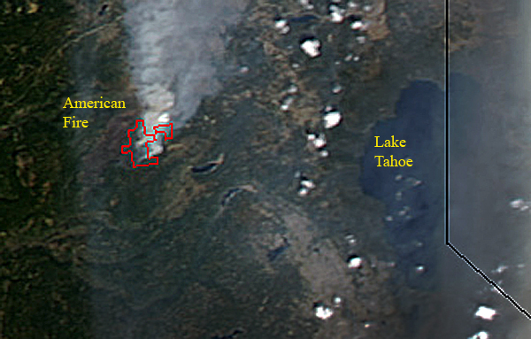
Tahoe National Forest officials have reopened parts of two popular trails damaged in August by the American fire and are seeking volunteers to help rehabilitate the remaining trail segments.

The Western States Trail is open between Michigan Bluff and Deadwood Cemetery, and OHV Trail Loop 6, also known as Forest Service Trail 11E44, is open west of Deadwood Ridge Road.

The entire fire area, including all trails and roads within it, will remain closed for public safety until May 1, said Gwen Ernst-Ulrich, forest spokeswoman.

The fire, northeast of Foresthill in Placer County, burned 27,440 acres within the forest’s American River Ranger District and surrounding properties, including three historic buildings at the Pacific Slab mine.

Eighteen of the 25 miles of the Western States Trail damaged by the fire have been rehabilitated, Ernst-Ulrich said, and efforts are underway to winterize the remaining seven miles to minimize erosion.

Since 1974, the trail has been the site each June of the internationally known Western States 100-Mile Endurance Run from Squaw Valley to Auburn and, in August, the Tevis Cup Endurance Ride.

The remaining damaged seven-mile segment, between Last Chance and Deadwood, is listed on the National Register of Historic Places. It includes two fire-damaged bridges across the northern portion of the middle fork of the American River canyon.

“The (ranger) district is looking at alternate routes for these events if the swinging bridge that crosses the river is not able to be used in time,” Ernst-Ulrich said. “Thousands of other recreationists use this popular trail annually.”

More at SacBee.com >>>

Forest service officials assess trails in American Fire area

American_Fire

Now that fire activity within the American Fire area has diminished, Tahoe National Forest officials have assessed conditions on two popular trails: the Western States Trail and OHV Trail Loop 6, also known as Forest Service Trail 11E44 (Loop 6).

The Western States Trail between Michigan Bluff and Deadwood Cemetery is open, and Loop 6 is open west of Deadwood Ridge Road. The entire fire area, including all roads and trails, is closed under Forest Order 17-13-08, which is in effect until May 1, 2014.

Therefore, the Western States Trail and Loop 6 within the fire area east of Deadwood Ridge Road remain closed. These trails will be returned to acceptable standards before being considered safe for recreationists.

The American Fire affected approximately 25 miles of the trail. To date, roughly 18 of those miles have undergone rehabilitation through fire suppression and/or burned area emergency rehabilitation efforts.

More at TheUnion.com >>>

1964 Highway 49 Bridge Rubble Remains A Cleanup Quandary

HWy49Bridge

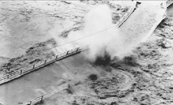
By most accounts, the Highway 49 bridge blowout of December 1964 was spectacular.

The Dec. 23, 1964, bridge washout put traffic on the Mountain Quarries Railroad Bridge for four months, and a new Highway 49 bridge was in place by spring of 1965. That year was also when the Auburn dam project was authorized by Congress. Though the dam was never built, the possibility that it would be constructed left the option of doing nothing open. The downstream rubble and steel the washout left behind would soon be under hundreds of feet of water.

Almost 50 years later, the dam has yet to be built and the remains of the bridge have yet to be cleared away – leaving a quandary for several levels of government, as well as environmentalists advocating greater use of the Auburn State Recreation Area as a park.

During fall days like Wednesday, when the American River flows are down to their lowest levels of the year, the mangled steel can be seen clearly in the river bed, some of the pieces poking up above the water line. The broken concrete – giant gray chunks weighing several tons – litters the canyon shoreline.

Elias Silver of the Lake Tahoe area was at the shoreline skipping stones with friends as their dogs romped in the calm, meandering waters at the confluence below the newer Highway 49 bridge.

“It’s definitely noticeable,” Silver said. “With all the state budget problems, it would be expensive to fish out. It’s not a small project.”

More at FolsomTelegraph.com >>>

Blasting From Folsom Dam Work Underway

The Army Corps of Engineers is excavating sections of the spillway for the new Folsom Dam. The corps will be blasting as it lays the groundwork to connect the American River with the new dam.

Chris Gray with the Army Corps says Folsom Lake Crossing Bridge will be closed from 1:30 to 2:30 in the afternoon for the next two weeks.

“We’ve more or less excavated the chute that’s part of the new spillway,” says Gray.  “That’s where the water will go when it leaves the new dam and connects to the American River. So that’s excavation’s done. Right now, we’re basically building that second dam.”

More at CapRadio.org >>>